Rathfarnham: a short history
By John Dorney
The Dublin mountains look down on Rathfarnham, once a rural village and now a sprawling suburb, creeping slowly up the slopes of the mountains.
The Rathfarnham area historically stretches from the first range of the Dublin-Wicklow Mountains to the river Dodder and border with Terenure to the north, Old Bawn to the West and Churchtown to the east.
It was once a frontier zone, separating the English-settled lowlands from the ‘wild’ mountain clans, then a rural retreat for the Dublin rich and hub of nineteenth century proto industry, and finally a site for endless suburban housing.
Rolling down from the hills, it is bisected many rivers and streams, principally the Dodder, the Owendower and Whitechurch stream.
The name Rathfarnham originally comes from the Irish Ráth Fearnáin which means The Rath or Fort of Fearnan. Rath, as opposed to Dun (as in neighbouring Dundrum) indicates an earthwork enclosure rather than a more substantial stronghold. Who Fearnan was, or where his stronghold was exactly, we do not know. But the long gone, probably iron age, chieftain is immortalised in the name of the area.
Early history
We may safely presume that settlements along the river crossings, particularly that on the hilltop over the Dodder, on the site of Rathfarnham village, go back to ancient times.
The first written record of Rathfarnham is when it was granted to Anglo Norman adventurer Milo Le Bret in 1199.
But the first extant written record of Rathfarnham dates back to 1199, shortly after the Anglo Norman conquest of Ireland, when lands at Rathfarnham were granted by the English Crown to one Milo Le Bret.[1] Le Bret, who accompanied the first wave of Anglo Norman invaders in Ireland, is thought to have been originally of Brittany in France and a tenant of Adam of Hereford, himself one of the followers of Richard de Clare or ‘Strongbow’ who spearheaded the invasion. Milo’s brothers received also lands in County Tipperary. [2]
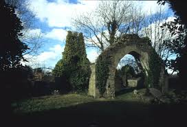
Like Norman conquerors everywhere, Le Bret and his followers put up a motte and bailey earthwork fortification to defend their holdings on an existing ridge, at what today is the meeting of Dodder Park and Braemor roads, beside Ely’s Arch (see below),[3] which is about a kilometre east of the site of today’s village.
However, within a short time, they had scouted a better site and Le Bret later set up a more substantial and permanent fortified settlement on the site of today’s Rathfarnham Castle. The the adjoining village of Rathfarnham gradually grew up around it. The village, on the crest of low north facing hill, overlooked the main ford over the river Dodder.
Le Bret did not neglect his spiritual duties (or perhaps better said, the demands of the Church) and soon erected a place of worship. The medieval Church, the ruins of which are located beside the present day Church of Ireland church in the village, dates back to 1212. [4]
In 1381 the first wooden bridge was built across the Dodder at Rathfarnham, where previously there had been a stony causeway. The wooden bridge was often destroyed by floods over the centuries. It was finally replaced by a stone bridge in 1765.[5]
In the early centuries of the medieval English presence, English settlement extended to the Royal Forest of Glencree, the second valley southwards in the Dublin Mountains. This gave Rathfarnham a buffer with the Gaelic Irish clans in the mountains the until 14th century.
But in that century, the English presence began to shrink, under pressure from plague, Scottish invasion and Irish resurgence. The estate at Glencree was overrun by the O’Toole clan and abandoned by the English. Thereafter, Rathfarnham came to be on the front lines of the newly created Pale, or fortified area around Dublin.[6]
For the following two centuries, the area was dominated by tough frontier or marcher lords. The Harold family settled in the area in the 13th century – giving their name to the area just south of Rathfarnham village; Harold’s Grange. The Harolds were tenants of St Mary’s Abbey and later of the Lord of Upper Ossory, and were responsible for protecting the south Dublin area from attack by the Gaelic mountain clans.
Like many another warlord clan, however, they were themselves often noted to be lawless and violent. In reign of Henry VIII, the Harolds had a small thatched castle and a mill at Rathfarnham. [7]
According to Maurice Curtis’s history of Rathfarnham, the Harolds later sold their holdings in Rathfarnham to the Eustace family but retained land further into the hills at Kilmashogue. [8]
Post Reformation
The late 16th century saw the Elizabethan English state gradually secure its control over the whole of Ireland, including rebellious upland areas such as the Dublin and Wicklow mountains. But this came at a cost for many of the pre-existing Pale community.
Many of the Old English families who had defended the Pale in Rathfarnham in medieval times were dispossessed after the seventeenth century wars of religion.
Many ‘Old English’ families such as the Harolds and Eustaces found themselves on the wrong side of the new Protestant English state, which, under the Tudor and Stuart monarchs, brought with the advance of state power, their state religion of Protestantism. This put many Catholic gentry families in a difficult position, caught between the rival pulls of their religion and their loyalty to the monarch.
The Eustaces were dispossessed of their lands in Dublin and Wicklow, including Rathfarnham, for their participation in the Catholic Desmond Rebellion of 1579-83.
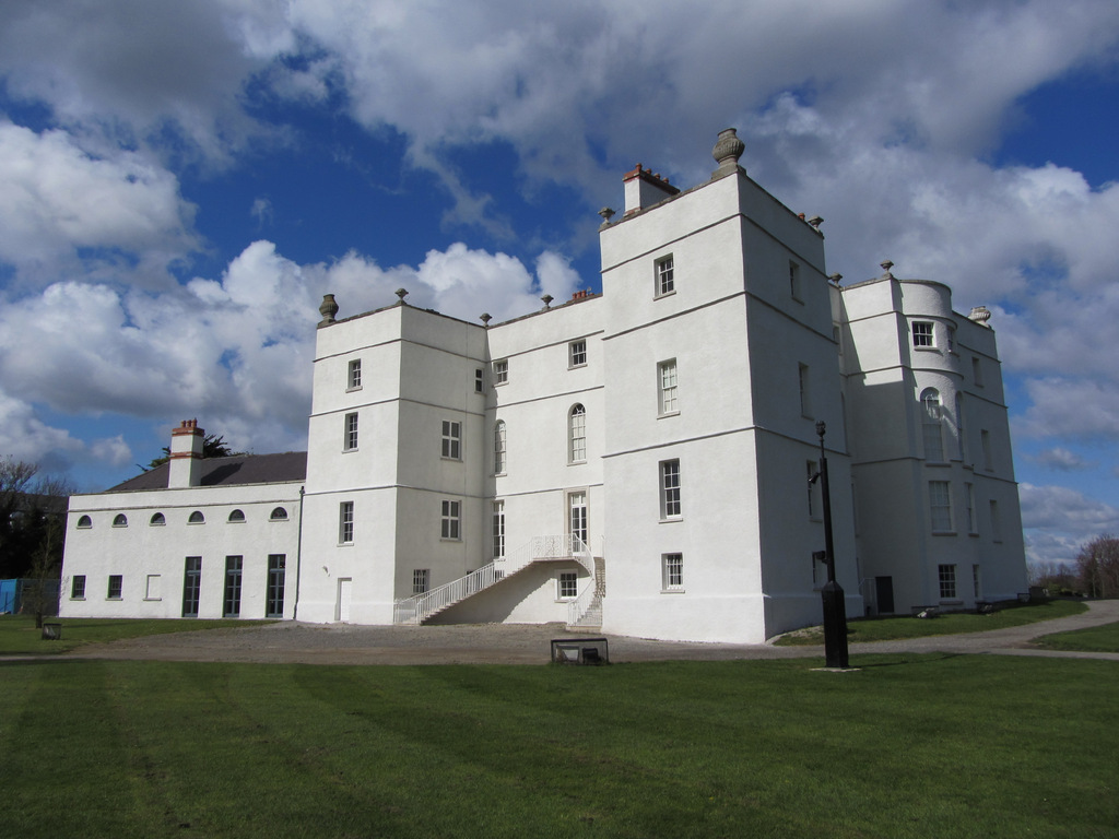
In 1583, at which time Rathfarnham was described as a ‘waste village’, it was confiscated from the Eustaces and granted to Bishop Adam Loftus. Loftus, the chaplain of the Lord Deputy, built Rathfarnham Castle on the site of an earlier structure as a fortified house. The Castle was attacked by Wicklow clans in 1600 in the Nine Years War and again in the Catholic rebellion of 1641. The Harold family apparently participated in this attack as they were later deprived of their lands in the Kilmashogue area of Rathfarnham for participation in the 1641 rebellion.[9]
Rathfarnham Castle also changed hands before the battle of Rathmines in 1649, when it was taken by the Earl of Ormonde’s Royalist forces. But after their defeat in the battle, it was reoccupied by the Parliamentarian forces of Michael Jones. Jones’ victory allowed Oliver Cromwell, to land in Dublin unhindered and the Lord Protector is rumoured to have himself spent some nights in Rathfarnham Castle on his way south to besiege Wexford.
Protestants decisively won the wars of religion in seventeenth century Ireland, but never became the majority in most of Ireland, even in locations such as Dublin where they were most concentrated.
In the era of the Penal laws, roughly from the 1690s to the 1790s, Catholics in Rathfarnham heard mass secretly in the ‘penal house’ off Willbrook Road and then from 1730, the ‘Mass House’ in the same location, not being allowed to openly build churches.[10] The mass house later became a church as the enforcement of the Penal Laws was relaxed over the 18th century. However, it was not until 1873 that the current Catholic Church of the Annunciation, was built in Rathfarnham. [11]
In this era also, though Rathfarnham became home to various and diverse religious groups, including Quakers and Moravians, (an evangelical sect who arrived in Ireland in about 1750) who established a Church and cemetery off Whitechurch Road.
From Castles to Country Houses

If Rathfarnham was often a violent and lawless frontier zone up the mid 17th century, one hundred years later it looked very different. By the mid 1700s it had become a preferred location for the merchants and gentry of Dublin to construct their country residences.
Rathfarnham village had largely grown up to serve the needs of neighbouring Rathfarnham Castle, and in 1618 it was given a patent to hold horse and cattle fairs, which were held in May, July and October at Butterfield Lane, just south of the village.[12]
In the eighteenth century, many of Dublin’s elite built themselves country houses in Rathfarnham.
Rathfarnham Castle itself and its large estate was held by the Loftus family until 1732 when it passed by marriage to the Whartons, who sold it William ‘Speaker’ Connolly (Speaker of the Irish Parliament) for £62,000. It subsequently passed through several different owners, including Dr Toady, the Bishop of Armagh and Bellingham Boyle, before being bought by Nicholas Loftus 1767, a descendant of Adam Loftus, the original owner.
The Loftus family, who gained, along the way, the title of the Earls of Ely, remained the main landowners and political power in the area well into the nineteenth century.
His uncle, Henry Loftus, Earl Ely, remodelled the castle from a fortress to an elegant Georgian mansion. He also built the triumphal arch (known as Ely’s Arch) at entrance to the estate. [13]
And Rathfarnham Castle was only one of several stately residences built in the Rathfarnham area in the 18th century.
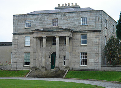
The La Touche family, a merchant dynasty of Huguenot origin, constructed what is now known as Marley House (its estate is today Marlay Park) in the 1780s.
Another prominent family, the Taylors, who counted among their numbers Thomas, the Lord Mayor of Dublin in 1750, and who came to own much of the lands around Grange Road, built a mansion and a deer park at Kilmashogue, which was later enlarged by La Touche family in 1781.
What is now Loretto Abbey was built in 1725 as the huge stately home of William Pallister. It was purchased by Loreto Order in 1821.
Berwick House, built near Nutgrove by Sir John Lamprey, later 1836, Hazelbrook, later name give to dairy across the road. Major Hall built the Bottle Tower monument nearby.[14]
The estate that today is St Enda’s was originally known as the Hermitage, and its house and walled demesne were erected by Edward Hudson, a prominent Dublin dentist, in mid eighteenth century. Hudson, a keen antiquarian, built many ‘romantic ruins’ on his estate, including mock castles and temples, a Dolmen, and a mock abbey. The Hermitage was later owned by Major Doyne, who had fought at the battle of Waterloo and Richard Moore, attorney general. [15]
Rebellions
Rathfarnham, like many other localities in Ireland, became a centre of radicalism in the 1790s, The republican Society of United Irishmen, would meet in the Yellow House pub, which was, in reprisal, destroyed by the authorities in 1803. There seems to have been strong element of class in political divisions in Rathfarnham. The United Irishmen recruited mill workers, while the loyalist Yeomanry militia were called out by the local landed magnate, Earl Ely.
However, for all the bloodshed in Ireland in 1798, the tranquillity of the gentry in Rathfarnham was only briefly disturbed in May of that year when there was a skirmish between United Irishmen, who seem to have been centred in the working class area of The Ponds, and Lord Ely’s Yeomanry.
Rathfarnham was the site of a skirmish in 1798.
Several insurgents were killed and wounded and their leaders Keogh and Ledwich were captured. Post 1800, with United Irish guerrillas still holding out in the mountains, Rathfarnham became the staging post for the Military Road, which the British Army built to access the Dublin and Wicklow highlands.[16]
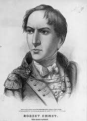
Robert Emmet, who led the abortive rebellion of 1803 was known to visit his girlfriend, Sarah Curran in Rathfarnham and later leased a house near the village. After the failed insurrection in Dublin city, his housekeeper, Anne Devlin, who lived near the Yellow House, was arrested and tortured to reveal his whereabouts, but refused to cooperate.
It was not until the dawn of the twentieth century, under the Land Acts that the great estates of Rathfarnham began to break up. Rathfarnham Castle estate, for instance, was sold and divided in 1913. The eastern part became a golf links, while the castle and the south western portion were bought by the Jesuit Order and the north western part was devoted to housing. [17]
Similarly, Kilakee House, home of the Massey family, who owned much of the land on the northern slopes of the Dublin mountains in Rathfarnham, lost much of their estate to the Land Acts and to debt in the early 1900s.[18]
Mills and industry
If Rathfarnham served as a pleasant location for Dublin merchant and gentry class in the 18th and 19th centuries, it also became a hub for proto-industry, particularly water mills, which powered a number of industries from the 1690s until the late 19th century.
Rathfarnham has three rivers all running south through it from the mountains: the Dodder, the Owendoher and Whitechurch Stream. All three were extensively harnessed before the twentieth century to power water mills, which for much of the 18th and 19th centuries, were used for the paper trade.
In the 17 and 1800s, water mills powered Rathfarnham’s paper industry.
Paper was made by immersing linen rags in a circular vat where they were beaten or ground into a watery pulp, hence the expression that somebody “was beaten to a pulp”.[19]
In Rathfarnham itself, there were several paper mills, one at the bottom of Church Lane, which ran from the village of Rathfarnham, down to the river Dodder, in front of Woodview cottages. It was first established by William Lake of Rathfarnham, in 1719 but later taken by over by William and Thomas Slater.[20]
Thomas Slater was the most prominent paper producer in Rathfarnham and was also known as a publisher who supplied the principal Irish printers of the period. It was claimed that Slater’s paper was far better than any French product.[21]
Like many another successful businessman, Slater’s success was in part due to the lucrative acquisition of public funding. In 1737, Slater petitioned parliament to establish a new mill “after the best such manner”. He claimed he was the only manufacturer of writing paper, in Ireland at the time. Parliament granted him a premium of £500 (£1,500,000 in present day values) and some 16 years later gave him a further grant of £350. [22]
Unfortunately for Slater, the Paper Mill here was run by William and Thomas Slater, was destroyed by fire, putting him out of business. Later paper mills on same site, just downhill from Rathfarnham village, were run by the Freeman and Teeling families. Later still, in 1836-39, Henry Hayes Paper mill was recorded on the site. [23]
Elsewhere in Rathfarnham there were many other mills; the Silveracre Mill, later renamed Brooklawn Mill, at Wilbrook along Whitechurch stream, Sweetman’s Mills off Butterflied Avenue, Ely’s Mills, beside Rathfarnham Bridge and Newbrook Mill near Taylor’s Lane to name but some of them. [24] [25]

The mills of Rathfarnham, did much to define the social character of the area. Each mill needed a pond and the area off Nutgrove Avenue which housed many labourers’ cottages was known as ‘The Ponds’. The Ponds area was first built in the early 18th century and the last cottages were not demolished until the 1950s.[26] Perhaps significantly the United Irish rebels in 1798 seem to have drawn their support in Rathfarnham from The Ponds area.
The advent of steam power and competition from mechanised paper factories in England gradually put most of the small, water powered Irish paper manufacturers out of business in the 19th century. Some diversified into cloth or flour (or in one case, wire) production, but by the twentieth century most of the mills in Rathfarnham were no longer in use for industry.[27]
Despite its preponderance of water-powered industry, Rathfarnham in the early 1900s was still predominantly rural. According to the 1911 census, its population in that year was 1,898. [28]
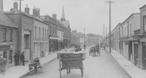
Nevertheless, by that time it was gradually being drawn into the wider metropolitan area. Horse drawn tram lines were extended to Rathfarnham in 1879, and the Dublin Tramway Co. electrified the number 16 route in 1899. In 1939, the number 16 tram line was replaced by a bus service of the same name. [29]
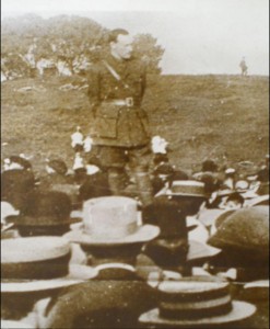
The most famous inhabitant of early twentieth century Rathfarnham was undoubtedly Patrick Pearse, the leader of the 1916 Rising and declared ‘President’ of the Republic during the insurrection. Pearse located his experimental Irish language school at the Hermitage, which he remained St Enda’s, from 1910 until 1935. Many of its past (and some of its present) pupils, followed Pearse into the insurrection at Easter 1916.
After Pearse’s execution in 1916, the school was run by his sister Margaret. It passed into public ownership in 1968, on her death. It is now a museum.
Rathfarnham did not escape the turmoil of nationalist revolution in the year 1919-1923. There were numerous raids and shootings in the area, which housed an RIC police barracks. Among the victims was a Volunteer Sean Doyle, who lost his life in British raid on an IRA training camp in the mountains at Kilmashogue. The police barracks in Rathfarnham village was blown up in 1923, during the Civil War.
An explosion of housing
It was not nationalist revolution, however, but urban sprawl that was to change utterly the character of Rathfarnham.
Form the 1940s onwards, the area became of site for middle class suburban housing, with its signature identical concrete semi-detached houses. Today, many of these stretch from the river Dodder almost down to the hills in the south.
In 1969, a shopping centre arrived in Rathfarnham, down river from the village. From the 1960s also date a series of working class public housing estates at Nutgrove, and from the 1980s another shopping centre in the same neighbourhood.
Suburban development totally changed Rathfarnham’s character in the late twentieth century.
By the 1990s, the area’s population had ballooned to some 17,000. It was perhaps fortunate that the one time grounds of the area’s big houses were largely preserved in parks or golf courses, allowing Rathfarnham to retain some of its rural character.
In the 2000s the M50 motorway was bludgeoned through the foothills at the southern edge of Rathfarnham, with its multiple lanes of traffic in either direction, belching and roaring through what was once quiet countryside.
But it is still possible to stand on the steep grassy hill, leading from the ruined Church at Rathfarnham, down to the Dodder river, to think of Milo Le Bret, the first settlers here, and of the past.
Sources
[1] Rathfarnham Roads, By Patrick Healy (2005) P. 1,
[2] Proceedings of the Battle Conference, Dublin 1997.
[3] Healy, Rathfarnham Roads, P.7
[4] Rathfarnham, Dublin Anglican History.
[5] South Dublin County Council Rathfarnham chronology
[6] Healy Rathfarnham Roads P. 7
[7] Healy Rathfarnham Roads P.42
[8] Rathfarnham by Maurice Curtis, The History Press, 2013. P.13
[9] Healy, Rathfarnham Roads pp.11, 42
[10] Rathfarnham Penal House and Mass House.
[11] Rathfarnham Catholic Parish History.
[12] Curtis, Rathfarnham, p.25
[13] Healy, Rathfarnham Roads p.12
[14] Healy, Rathfarnham Roads p.25
[15] Healy, Rathfarnham Roads p.35-36
[16] Healy, Rathfarnham Roads P. 27
[17] SDCC Chronology
[18] See, Frank Tracy, The Masseys of Kilakee, for details https://localstudies.wordpress.com/2013/04/24/the-massys-of-killakee/
[19] An Irishman’s Diary, The Irish Times, January 15, 1996, https://www.irishtimes.com/opinion/an-irishman-s-diary-1.21908
[20] Healy, Rathfarnham Roads p.17
[21] An Irishman’s Diary, Jan 15, 1996
[22] Irishman’s Diary, 15 Jan, 1996
[23] Healy, Rathfarnham Roads p.18
[24] Healy Rathfarnham Roads p. 73
[25] Mills of Rathfarnham http://www.askaboutireland.ie/reading-room/history-heritage/built-heritage-1700-today/the-mills-of-south-dublin/the-mills-of-rathfarnham/
[26] Curtis, Rathfarnham, p.52
[27] Irishman’s Diary, Jan 15, 1996
[28] https://www.google.com/url?sa=t&rct=j&q=&esrc=s&source=web&cd=14&ved=2ahUKEwjJnezzxqDiAhVuSxUIHV6cARcQFjANegQIABAC&url=http%3A%2F%2Fwww.glorchluainin.com%2Fwp-content%2Fcensus%2F1911_Census.doc&usg=AOvVaw0l2xXB_zu-iR5KoLGBSjqN
[29] Curtis, Rathfarnham, p.42, Healy, Rathfarnham Roads, p27